


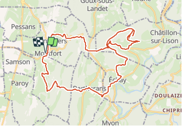
fait le 29-12-2023 Montfort

gerardmicheline
User

Length
23 km

Max alt
560 m

Uphill gradient
690 m
Km-Effort
33 km

Min alt
308 m

Downhill gradient
690 m
Boucle
Yes
Creation date :
2023-12-19 07:38:06.531
Updated on :
2023-12-19 14:48:47.728
5h33
Difficulty : Very difficult

FREE GPS app for hiking
 SityTrail
IGN / Geographical institutes
SityTrail Plus
The world is yours!
About
Trail Walking of 23 km to be discovered at Bourgogne-Franche-Comté, Doubs, Le Val. This trail is proposed by gerardmicheline.
Positioning
Country:
France
Region :
Bourgogne-Franche-Comté
Department/Province :
Doubs
Municipality :
Le Val
Location:
Montfort
Start:(Dec)
Start:(UTM)
720130 ; 5215662 (31T) N.
Comments